

XENIA — Greene County will be under a Winter Storm Watch beginning at 9 p.m. Wednesday through 7 a.m. Friday.
WDTN meteorologists expect the watch to be upgraded to a warning at some point.
Rain will continue, heavy at times, through the day Wednesday. WDTN said street crews will not be able to effectively pre-treat roads, because of the heavy/prolonged rain expected. Sometime in the afternoon, snow will develop across the northwest counties in the Miami Valley, where snowfall totals will end up being the highest.
An area of mixed precipitation will expand Wednesday night into Thursday morning. Travel will become hazardous if not impossible in spots, with freezing rain and sleet, WDTN posted on its website. Snow will also expand and continue across the north during this time.
During the day Thursday, the snow line will continue its way south, and the icy mix will be limited to the far southeastern counties by Thursday evening.
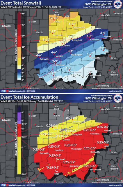
“We expect ice totals to range from a tenth of an inch to as much as a half inch in spots that see freezing rain the longest. This could cause isolated to widespread power outages,” according to WDTN meteorologists.
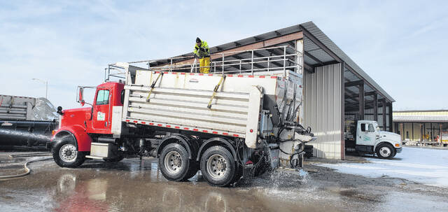
Snow will come to an end early Friday, and street crews will then have time to catch up. Road conditions will likely be poor in the morning, but improve through the day. Snow pack in much of the Miami Valley will hang around for a while, as it turns a lot colder behind this system.
Northwest Greene County is in the 4-6 inch range while the rest of the county falls in the 2-4 inch range.
The forecast as of Tuesday night by the National Weather Service office in Wilmington calls for:
Wednesday morning and afternoon
Rain, mainly after 9 a.m. High near 44. South wind 6-11 miles per hour. Chance of precipitation is 100 percent. New precipitation amounts between a quarter and half of an inch possible.
Wednesday night
Rain before 4 a.m. then rain, possibly mixed with freezing rain. Low near 26. Light and variable wind becoming north 9-14 miles per hour. Chance of precipitation is 100 percent. New ice accumulation of less than .1 of an inch possible.
Thursday morning and afternoon
Snow, possibly mixed with sleet, becoming all snow after 4 p.m. The sleet could be heavy at times. Patchy blowing snow after 3 p.m. High near 29. Blustery, with a northeast wind 14-20 mph, with gusts as high as 31 miles per hour. Chance of precipitation is 100 percent. New snow and sleet accumulation of 1-3 inches possible.
Thursday night
Snow, mainly before 2 a.m. Patchy blowing snow between 9-11 p.m. Low around 14. Blustery, with a north wind 15-20 miles per hour, with gusts as high as 31 miles per hour. Chance of precipitation is 100 percent. New snow accumulation of 1-3 inches possible.
Friday morning and afternoon
A slight chance of snow before 9 a.m. Mostly cloudy with a high near 21. Chance of precipitation is 20 percent.
Friday night
Partly cloudy, with a low around -5.


